 |
|
|
|
||
Activities and Aim of the ProjectObjectivesOne objective of the project is the generation of numerical-geotechnical forecast- and risk models for the assessment of slope stabilities and possible rock falls. They allow reliable statements of the en-dangerment by mass movements. The models can be adjusted to future changes of climatic conditions (e. g. heavy rainfalls). This is accompanied with the establishment of engineering solutions for the underground in respect to the infrastructure as well as of safety concepts for future construction measures at risky slopes. Another important objective is the further development of a low-maintenance monitoring- and early warning system which covers larger and poorly accessible areas. Based on a combination of existing technologies a self-learning monitoring system of mass movements will be developed as an early warning system. This flexible system can be adjusted to different geotechnical situations. Within the planned expert system all existing and generated data with space- and time reference are stored. In addition, rock-mechanical and hydrological properties will be implemented. The expert system allows a systematic record of mass movements and can be extentend beyond the project time. With the growing collection of new data one obtains a step-wise more precise knowledge of kind and intensity of the natural risks in Svaneti. The monitoring- and early warning and the expert system will be connected so that possible local endangerments and concrete incidents will be automatically shown in the WebGIS. This enables authorities to react with appropriate measures in a shorter time. The further developed application for smartphones and tablets allow a prompt information of the authorities of incidents. The aforementioned objectives lead to a sustainable prevention or at least reduction of casualties and the destruction of the infrastructure. Future constructions can be realised in an economic more efficient manner since a planned work prevents the actual permanent reworks and additional costs. The developed administrative framework with recommended actions enables public authorities to react in a systematic and coordinate way in case of incidents. Another objective is an application for smartphones and tablets so that people can report mass movements, leading to an increasing awareness of the local people. Furthermore, this „crowd data collecting“ enhances the data availability and thus, can improve future forecast models and the planning reliability. Together with our Georgian partners we will carry out different geoscientifical investigations and install a monitoring system within the project which is funded by the the German Federal Ministery of Education and Research. You get more information about our work and the aim of the project here.
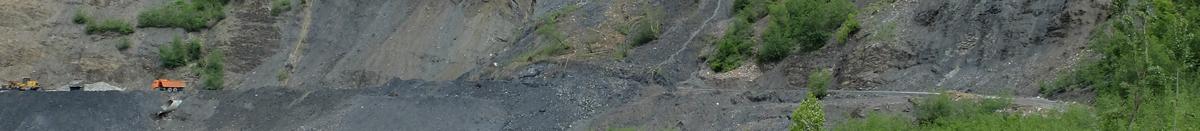
ApproachSpecific areals will be surveyed by drone flights for a following generation of digital elevation models (DEM). This DEM are a prerequisite for the flood modelling as well as geotechnical forecast- and risk models. The geo-environmental conditions and rock mass parameter will be systematically determined with engineering-geological investigation in specific areas in Svaneti. This results are the prerequisite for the generation of geotechnical forecast- and risk models as well as flood modeling One approach is the connection of this models to illustrate the direct connection between flood incidents and endangerment by mass movements. Parameter and values which result from flood modeling will be used fort the geotechnical forecast- and risk models. Existing monitoring- and early warning systems range from complexe satellite-based systems over fibreoptic cables with a partly high installation efford to simple robust systems like sensors, extensometer, sending the signals commonly via GMS/SMS. Experience so far show that satellite-based systems are very complex and elaborate. Thus, a robust system will be locally installed which can be extended step by step. To cover larger parts of the vast project area with an economically justifiable monitoring system an initial calibration of this system will be carried out by geotechnical forecast- and risk models. This is followed by a step by step machine-learning recalibration. For this purpose it will connected with the expert system to program corresponding algorithm.
Surveying and engineering geological investigationsDrone flights are used surveying in selected areas in order to create digital terrain models in different resolutions. The degree of resolution will be higher within the areas of investigation and risk type localities yet to be defined to obtain a sufficient degree of detail. Based on the evaluation of existing data, environmental and engineering geological explorations as well as mapping will be performed in selected areas. The investigations will result in a comprehensive knowledge about the risk potential for the population and infrastructure. Weighting of the various impacts and classification of the respective risk levels will be performed to define areas for the generation of geotechnical forecast- and risk models. Using existing spatial data, the flood risk will be tentatively assessed and, based on this, pilot areas for flood modeling will be selected. The analysis and modeling will allow the definition of risk type localities. All data will be integrated into the expert system.
Forecast- and risk models for slopes and the underground
In selected reference areas, numerical geotechnical forecast- and risk models will be generated in respect to rock falls and mass movements. The models can be adapted to changing environmental conditions. Focus is placed on the link with the flood modeling and climatic impacts (e. g. storm events, thawing of permafrost soil) to quantify the impact of such events on the stability of slopes and the subsurface. In this context, also analytical approaches such as slope stability calculations will be applied.
Safety concepts and constructive solutions
Safety concepts will be developed according to the defined risk type localities and the results of the risk models. This includes different solutions of geotechnical slope stabilisations (rock fall protection, anchors, protective nets, etc.), retaining walls (gabions, bolted walls, dry stone walls etc.) as well as green engineering measures (slope planting, fascines, etc.). The project intends to develop new and innovative construction methods that combine technical and biological engineering approaches. Decisive for the success of these methods is the consideration of typical regional plant species and subsurface conditions. The acquisition of such boundary conditions will be conducted on site during the field campaigns. Constructive measures will guarantee stability and erosion control before such functionality is provided by the plant cover.
Expert systemThe expert system comprise a GIS-server with a database and a WebGIS component. It is a central tool to manage and visualise already existing data (geology, natural risks, land use, air photographs ...), processed information from satellite images, field data as well as modeled data from the monitoring- and early warning system. Only open-source software will be used to prevent licence costs so that it becomes applicable for Georgian authorities and professionals. Core components are QGIS, PostGIS and the GBD WebSuite. The WebGIS component offers authentificated users from authorities and professionals a comprehensive overview of the different risks of endangerment and is a basis for a sustainable regional planning. An analysis modul will be programmed for the WebGIS which enables this user group to carry out statistic evaluations or spatial analyses. Furthermore, information can be offered to policymaker and the general public. The expert system will be connected with a tool box „mass movements“ which will be programmed for the desktop GIS. GIS specialists from authorities and other professionals can execute comprehensive editing and different analyses and extend and optimise the expert system with this results. One particular emphasis is the realisation of an efficient processing of a large amount of data (Big data) especially of satellite-based data. An application for smartphones and tablets will be further developed so that people can report incidents by taking a photograph, giving a short description and uploading this information to the database. This reports will be proved by professionals before they will be shown in the WebGIS.
Monitoring- und early warning system
The monitoring- und early warning system comprises sensors which sends measured data of movement, temperature and moisture to a local gateway either in defined intervals or immediately in case of hazards. The gateways sends this information directly to responsible persons as well as to a central server (SMS, E-Mail). Measured data can be correlated with measured data from other sensors in the area as well as their time range. This makes it possible to send detailed information of possible movements as well as to obtain a long-term risk assessment of the monitored area.
Administrative recommendations for actionsAn approach for a risk management will be developed based on the results of the different work packages. Intensified public relation acitvities shall increase the awareness of the local people, property owners and acting companies about the local risks and possible risk provisions. |
||